New NR Nominations (January 2025)
The following nominations were approved by the Governor's Consulting Committee and subsequently by
the Keeper of the National Register of Historic Places during fiscal year 2024, and are now
listed in the National Register. They represent a diverse range of historic resources across the
state, and include new nominations, amendments to previous nominations, as well as a Multiple
Property Document Form that will provide the basis for evaluating the National Register
eligibility of related properties.
Each entry is followed by its jurisdiction and its associated inventory number on the Maryland
Inventory of Historic Properties (MIHP).
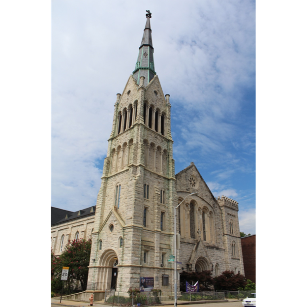 Bethel AME Church (B-123), 1300 Druid Hill Avenue, looking northwest
Old West Baltimore is a large, approximately 175-block area northwest of downtown Baltimore. It
consists of a group of neighborhoods now known as Madison Park, Upton, Druid Heights, Harlem
Park, and Sandtown Winchester. While primarily composed of rowhouses, there are also religious
and institutional buildings scattered throughout the district, as well as a commercial area
along Pennsylvania Avenue.
The Old West Baltimore Historic District was listed in the National Register of Historic Places
in December 2004. While the original nomination extensively documents the historic development
of the district and the people within it, it does not discuss in detail significant people,
sites, and activities associated with the Civil Rights Movement. This amendment, listed under
the 2020 Civil Rights in Baltimore Multiple Property Documentation Form, provides this
detailed documentation, and amends the original nomination to add Social History/Civil Rights
as an area of significance, drawing on the “Segregation and the Fourteenth Amendment”
and “The Great Depression and World War II” historic contexts. One building highlighted in
this update is the Bethel AME Church, which in the early 20th century had the largest Black
congregation in Maryland and was “a center of the black struggle for equality… it was used
for meetings to discuss political issues affecting the entire Baltimore community” (Afro-American
1987, A6). The Rev. Harrison J. Bryant, pastor between 1948 and 1964, was an ardent Civil
Rights activist, and a prominent congregant of the church was John H. Murphy Sr., publisher
of the Afro-American newspaper.
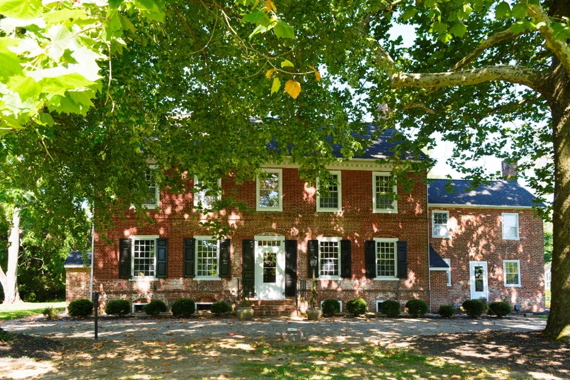
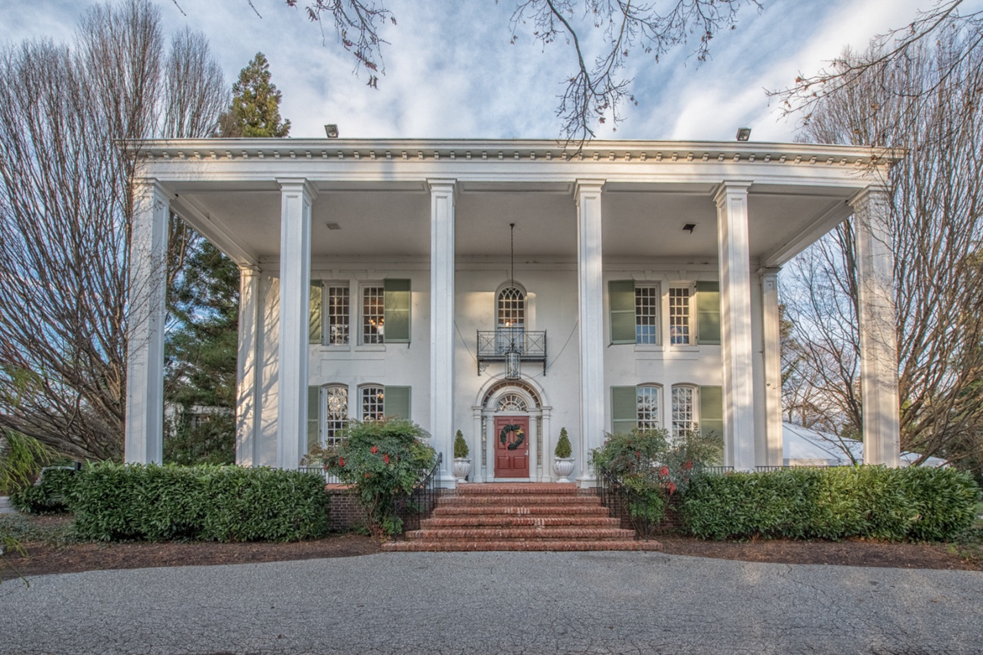 Grey Rock Mansion
Exterior, Front Portico and Entrance,
facing north
This large three-story masonry building is located in Pikesville, Maryland, on the site of the
historic Howard family homestead, birthplace of John Eager Howard, who served as Colonel during
the Revolutionary War and as Governor of Maryland from 1788-1791. Howard descendants sold the
property to Dr. Richard H. Maynard in 1857, who constructed an Italian Villa-style mansion
between 1857 and 1861. It was named “Grey Rock” for the local natural grey rock used in its
construction. It had a stucco exterior and was designed by the well-known Baltimore architect
Nathan Gibson Starkweather, who also designed several other residences for prominent Baltimore
families.
In 1923, the property was sold to A. Ray and Ethel Epstein Katz, who, working with architect
Benjamin Frank, extensively renovated the residence. Ethel was the daughter of Jacob Epstein,
founder of one of Baltimore’s largest businesses, and one of the city’s most prominent
philanthropists, who helped establish the Baltimore Museum of Art and the Johns Hopkins
Homewood campus. Under the stewardship of Ray and Katz, Grey Rock Mansion was transformed
into a Greek Renaissance or Classical Revival style mansion, copying several elements from
well-known residences like Mount Vernon. The house is significant as a superb example of
architectural and interior design trends of the 1920s, particularly that of the colonial
revival architecture and historic furnishings.
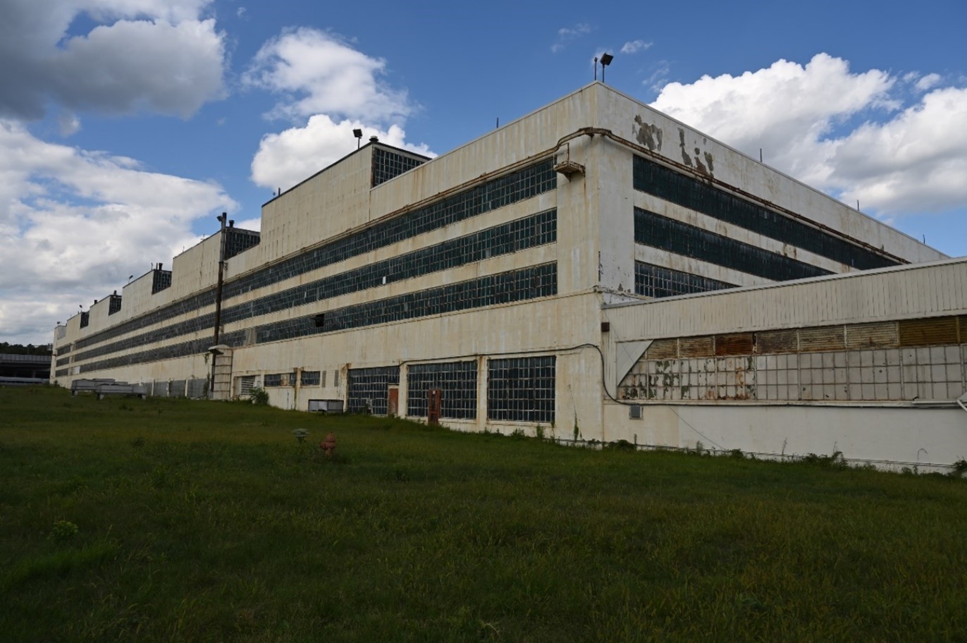 Glenn L. Martin Plant #2
West wall, looking northeast
The Glenn L. Martin Company Plant #2 is located to the north of the Martin Airport in Middle
River, Baltimore County. It was built between 1940 and 1942 as a satellite facility just
east of Martin Plant #1, specifically to produce B-26 Marauder bombers for the Army. The
architect for both plants was the renowned Albert Kahn; he designed Plant #2 in an Art
Moderne Industrial style, with simple geometric shapes and horizontal orientation. Kahn
employed this style with his larger industrial plants, as the overall form accommodated the
manufacturing process required to produce a large-scale product efficiently.
Of the total 5,266 B-26 Marauder bombers produced during the Second World War, 3,572 were
produced in Plant #2. The plant is significant for its role as the primary production
facility for the bomber from late 1941 to 1945; for its association with Glenn L. Martin,
one of the top military aircraft designers in the country; and as a major work of Kahn,
the premier industrial architect in the United States during this period.
 Park Heights Historic District
5000-5016 Denmore Avenue,
facing west
The Park Heights Historic District comprises historic resources built between 1906 and 1960 in
an area of Baltimore City north of the Park Circle National Register Historic District,
extending northwards to Northern Parkway between the Western Maryland rail line on the
west and Greenspring Avenue on the east. From detached frame houses through dense rowhouses,
the district documents the evolution of the concept of “suburb” throughout this period. Its
residential rows offer examples of the range of architectural influences and building types
that characterized the city during the early- to mid-twentieth century and represent the work
of noted and prolific local developers and builders, while its churches and synagogues embody
the distinctive designs of prominent Baltimore and D.C. architects.
There was an influx of Jewish residents to this area by the 1920s, and the entire area became
a Jewish neighborhood in the 1920s, with four major synagogues opening between 1921 and 1928.
By the late 1960s, many of these residents had moved further north to Pikesville and Baltimore
County, and had sold their homes to African American families -- many from the Caribbean islands
of Jamaica, Trinidad, and Haiti -- who were as eager to escape the confines of the old city
below North Avenue as the Jewish families had been a generation previously. The Park Heights
neighborhood is probably best known as the location of the historic Pimlico Race Track, the
second oldest race track in the United States, and home of the Preakness Stakes.
 Worsell Manor
Main House, front, looking west at east elevation
Worsell Manor is located near the end of a country road, two and a half miles northwest of
Warwick, in southeast Cecil County. The complex consists of a mid-Georgian brick manor house
and several nineteenth- and twentieth-century barns and outbuildings, including a
nineteenth-century timber frame barn and granary, two concrete silos, a concrete block dairy,
and a pole shed. The house sits back from the road on a pastoral, flat open site, and the ground
slopes down to the north and northeast of where the adjacent outbuildings are located. The house,
likely constructed ca. 1760-80, is two and a half stories tall, five bays wide by two bays
deep, and laid in Flemish bond. It retains much of its original fabric.
The property originated as a thousand-acre land grant from Charles Calvert, 3rd Lord Baltimore
and proprietor of Maryland, to Peter Sayer, in 1683. Though the property retains only fifty
acres of its original thousand acres, the landscape retains its rural character and agricultural
setting. In the seventeenth century, tobacco was the cash crop in Tidewater Maryland; by the
mid- to late-eighteenth century, wheat was the primary export crop of the upper Easter Shore
and stayed as such into the twentieth century. By the 1950s, dairy farms were abundant in the
county, of which Worsell Manor was one. The Worsell Manor dwelling house is significant as
an outstanding example of an elite early planter’s residence and plantation in Tidewater
Maryland during the mid-eighteenth century.
 St. Dennis Roman Catholic Church, facing southwest
The St. Dennis Roman Catholic Church Complex is a discontiguous historic district comprised of
three contributing resources: a cemetery, rectory, and church, as well as one non-contributing
resource, a garage, in the town and vicinity of Galena in northern Kent County. The church,
rectory, and garage share a parcel that is located on the northern side of the Town of Galena,
on the west side of Maryland Route 213. The St. Dennis Cemetery and the site of the first (c.1855)
parish church is located approximately 2.4 miles to the south. The current St. Dennis Church
building was constructed in 1934 as the congregation’s third church. It is constructed of
stone in the Gothic Revival style and is connected by a hyphen to the 1884 rectory, which is
constructed of brick that is believed to have been used in the building of the original, no
longer extant, church.
The church complex is significant for its association with the historic settlement patterns of
Kent County. The history of the parish is interconnected with the development of the surrounding
communities of Lambson and Galena. The church developed in response to the religious development
of the area, as Catholic parishes were not commonly found in Kent County as compared to Methodist
or Episcopal parishes. The complex is further significant for both the church and rectory’s
architecture. Designed by the Philadelphia firm, Gleeson & Mulrooney, the church is a representative
example of the English Gothic style of ecclesiastical architecture, exhibiting a refinement of
design and workmanship not commonly found in rural settings. The rectory exhibits an eclectic
array of Victorian styles, including gothic revival and Queen Anne elements. Its dedicated office
space was an unusual feature for rectories of the period.
 Griffith House
View looking west at east elevation of Griffith House
The Griffith House, sometimes called Cranberry Hall by twentieth-century writers, is located on
a knoll surrounded by a lawn with mature trees and shrubs; the property is bounded by U.S. Route
40 to the north, and is located about a mile from the Aberdeen Proving Ground in Harford County.
The house was listed in the National Register of Historic Places in 1978. This additional documentation
clarifies the National Register criteria, area of significance, and period of significance, and
provides a resource list, a description of non-contributing resources, and a comparative analysis
of similar properties.
Likely constructed during the ownership of John Hall (1719-1779), frequently referred to as John Hall
of Cranberry, Griffith House is noteworthy as a rare surviving example of a traditional or vernacular
style hall and parlor house, constructed in the first half of the eighteenth century in Harford County.
Although changes have been made to the house over the years, it still retains its small folk/traditional
form and maintains its gambrel-roof profile. This amendment to the original nomination clarifies the
building’s period of significance as ca. 1747, when the dwelling was constructed, and makes clear that
the outbuildings on the property are non-contributing, as they were built outside the period of
significance. According to historian Christopher Weeks, the Griffith House is one of only a few that
presents “a reasonably clear picture of what life was like among Harford’s prosperous elite 30 years
prior to the Revolution.”
Upland (Baltimore City,
B-5339)
 Upland, south façade, facing northwest
Upland is a ca. 1914, French Eclectic-style, three-story stone dwelling in northern Baltimore City. The
property is west of Roland Avenue and on the north side of St. George’s Road.
Between 1914 and 1948, Upland was the dwelling of Edith Houghton Hooker, a women’s suffrage leader who
founded the Just Government League of Maryland, the most influential women’s suffrage organization
in the state.
The nomination is listed under the Women’s Suffrage Movement in Maryland Multiple Property Documentation
Form as a “property associated with prominent persons.” Hooker was born in 1879 near Buffalo, New
York. She graduated from Bryn Mawr College in 1901 and later was one of the first female students to
attend Johns Hopkins University School of Medicine. There she met Dr. Donald R. Hooker, and the
couple married in 1905. After a year studying in Berlin, the Hookers returned to Baltimore, where
Mrs. Hooker began her career in social work and public health. Together, she and her husband founded
the Guild of St. George, a home for unwed mothers and their children, and the Planned Parenthood Clinic.
It is unclear when Edith’s suffrage activism began, but she founded the Just Government League in 1907.
She hosted women’s suffrage events at Upland between 1914 and 1920; one of her house guests included
the well-known British suffragist, Emmeline Pankhurst. After passage and ratification of the Nineteenth
Amendment, Hooker continued to support women’s rights and served as the editor of Equal Rights, the
primary publication of the National Woman’s Party, while she lived in the house. The property is
associated with her most productive period of suffrage activism.
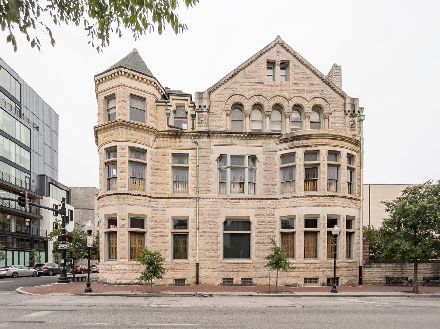 Maryland Club
Charles Street, west elevation looking east
The Maryland Club is a private social club founded in Baltimore in 1857; it was first permanently
located in a house designed by Robert Mills on Franklin Street. Many of its early members came
from Baltimore’s and Maryland’s elite in finance, government, education, law, and medicine. The
Club’s current headquarters building in the Mount Vernon neighborhood was constructed in 1891 in
the Richardsonian Romanesque style, and was designed by Josias Pennington, a native Baltimorean
who was best known for his railway buildings, especially those designed in collaboration with his
partner, Ephraim Baldwin. Despite notable demolitions on Charles Street, the Maryland Club’s
setting amidst the numerous stone and brick rowhouses of Mount Vernon has seen relatively little
change since 1900. Various additions for athletic activities have been made but have generally
not affected the original character and plan of the original building.
In the twentieth century, the organization’s members included financiers, leaders of the B&O Railroad
and other companies, Baltimore mayors, Maryland governors, U.S. senators, and diplomats. Author
H.L. Mencken was a constant presence in the Clubhouse for more than a decade, as were other writers,
academics, and doctors. Even though alcohol manufacture was illegal during Prohibition, members
kept their own alcohol stocks in lockers in the building. Over the twentieth century the Club
became increasingly associated with athletics. The Maryland Club is significant as a relatively
rare Richardsonian Romanesque building in the city, and as one of the few surviving social clubs
with close associations with Maryland leaders stretching from the late nineteenth century
to the present.
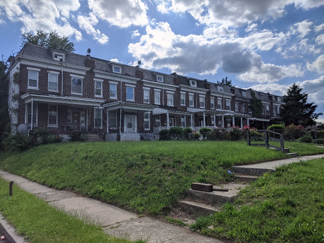
 Barclay/East Baltimore-Midway Historic District
2100-2110 Homewood Avenue
The Barclay/East Baltimore-Midway Historic District is a late nineteenth and early twentieth
century streetcar suburb located about two miles north of downtown Baltimore. Early industrial
development of the district prior to the area’s 1888 annexation by the city and a steeply graded
stream valley east of Greenmount Avenue combined to promote an unusually varied mix of industrial
and residential development across its approximately 138 acres of land. The district is significant
for its architecture as well as its community planning and development between the years
ca. 1875-1950.
The early use of the property for tanneries and other industrial land uses along with suburban
residential development such as cottage-style duplexes located in the northeastern corner of the
district is characteristic of pre-1888 annexation land use patterns. The district also illustrates
the transition from the pre- to post-annexation development of former suburban areas. Development
in this area, as in others, was greatly accelerated by the expansion of the electric streetcar
system in Baltimore, but also simultaneously complicated by conflicts over land use and the work
of incorporating the existing development into the growing city. In Barclay/East Baltimore-Midway,
these complications are particularly evident in the street grid, which combines grid patterns from
three distinct periods of development, reflecting the necessary compromises that city planners and
engineers made in developing the area during the late nineteenth and twentieth centuries.
Starr Church (Queen Anne’s
County, QA-367)
 Starr Church
View south of northwest elevation, with Church Hall in background
Starr Church is a ca.1860 frame meetinghouse in the crossroads village of Starr, southeast of
Centreville in Queen Anne’s County. The church, sited in a grove of oak trees, exemplifies the
Greek Revival style popular amongst Methodist congregations on the Eastern Shore during the
mid-nineteenth century. It is a gable-front building, three bays wide and three bays deep. The
interior retains a high degree of integrity, with original finishes intact. A fresco decoration
remains in the gallery, and an elevated side entrance that was used by enslaved and freed African
American members of the congregation are rare surviving architectural features. Also on the property
is a frame church hall. Originally a schoolhouse, it was moved to the site between 1927 and 1929.
The church is locally significant for its architecture, reflecting the local building traditions of
rural Queen Anne’s County, and as a local interpretation of the Greek Revival style. Its period of
significance is 1860 to 1929, from its date of construction to the last major architectural change
to the property. The fresco that remains in the gallery was painted by an unknown person in 1882;
the remaining frescoes were covered by paint in the 1970s. The segregated entrance for African
American worshippers is one of the better-preserved examples in the county.
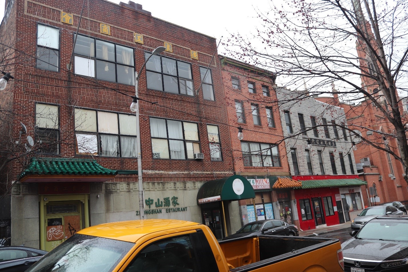 Chinatown Historic District
325-319 Park Avenue, looking southeast
The Chinatown Historic District is located in downtown Baltimore, within the Market Street National
Register Historic District. It is comprised of 25 buildings, of which 18 are contributing; the
district is commercial and urban in character, with no open spaces such as parks or landscaped
areas. Buildings are primarily of late nineteenth-century Italianate rowhouses, intermixed with
some early nineteenth-century and early twentieth-century buildings. Many of the structures retain
historic signage, some of which are in Chinese lettering, reflecting the district’s role as an
ethnic Chinese enclave between ca. 1920 and the late twentieth century.
Representing the largest extant, contiguous group of properties associated with Baltimore’s Chinese
population in the twentieth century, the Chinatown Historic District is nominated under the Asian
American Communities in Maryland Multiple Property Documentation Form. Between ca. 1920 through
1977, the 300 and 400 blocks of Park Avenue and the 200 block of W. Mulberry Street contained
numerous businesses and organizations established by and/or for Chinese and Chinese Americans,
all of which contributed to the flourishing of a distinct ethnic enclave in Baltimore. The extant
buildings illustrate the second iteration of the city’s Chinatown, after displacement forced
businesses and residents north on Park Avenue in the early 1920s. The Chinatown district is
closely associated with individuals and events with a significant connection to the history
of the Chinese American community in Baltimore. Several landmark restaurants were still
operating in the neighborhood in the 1970s, when community leader Calvin Chin and the
Chinese Consolidated Benevolent Association attempted to revitalize the area and celebrate
its rich cultural history.
 George Washington House, east façade and north elevation, looking southwest
The George Washington House/Indian Queen Tavern in Bladensburg was listed in the National
Register of Historic Places in 1974 for its role as an early commercial complex. It is a
five-bay, two-and-a-half story brick building with a two-story front porch that was built ca.1760
by Jacob Wirt as a store that was part of a larger complex that included a billiard hall, tavern,
and blacksmith shop. The building earned its moniker through the (unlikely) assumption that
George Washington once slept in the building. This amendment to the original nomination is part
of a larger project to document sites associated with the Women’s Suffrage Movement in
Maryland. The additional documentation adds Social History/Women’s History as an area
of significance.
Under the Women’s Suffrage Movement in Maryland Multiple Property Documentation Form, the
George Washington House is significant as one of the hotels used by members of the National
American Woman’s Suffrage Association’s (NAWSA) Army of the Hudson during its groundbreaking
1913 suffrage hike from New York to Washington, D.C. This hike represented a pivotal change
in tactics used by suffragists nationwide. The George Washington House was the last stop
along the 200-mile journey before the Army disbanded the following day. It was also the
site of a meeting between hike leader Rosalie Jones and Alice Paul, NAWSA Congressional
Committee leader, where Paul took the letter address to President Wilson that Jones had
carried along the entire journey with the intent of hand delivering it to Wilson, causing
divisions in the organization. The Army of the Hudson inspired similar hikes by the Just
Government League of Maryland, part of a tactic to bring women into public spaces and into
the public eye, garnering media publicity and attention to their cause.
 Emmitsburg Historic District
West Lincoln Avenue streetscape, facing southeast
Listed in the National Register of Historic Places in 1992, the Emmitsburg Historic District
is located at the northern tip of Frederick County. The original nomination focused on the town’s
early development and its Anglo-European population. It highlighted exceptional 18th- and 19th-century
architecture found principally on Main Street and documented Architecture and Commerce as areas
of significance. The south side of West Lincoln Avenue was not included within the district’s
boundary, nor was there any discussion of the town’s African American population. This amendment
highlights West Lincoln Avenue, an area of African American settlement which remained a Black
neighborhood through the mid-20th century and includes additional information to support a new area
of significance – Ethnic Heritage/Black. The boundary increase adds six homes to the Emmitsburg
Historic District, all of which are associated with African American ownership.
Black settlement along West Lincoln Avenue began in the late 1850s and represented a pattern of
formerly enslaved people creating small enclaves in northern Frederick County. Differing from
other Black communities in the area, it developed in an urban context surrounded by a
predominately white population. Like other areas of the district, the south side of the
block (included in the boundary increase) has residences set close to the street. Behind the
homes are large backyards with lawns. Several of the backyards include foundations from earlier
structures. The 165’-long lots back into a lightly wooded area, and beyond, to the southwest,
are agricultural fields. The street, which at one point included a “Colored School,” remained
a majority-African American neighborhood through the mid-20th century. Two of the homes
historically associated with Blacks are still owned by descendants, maintaining the
neighborhood’s continuity.
 Asian American Communities in Maryland MPDF
Chinese Bible Church of Maryland, Rockville
The Asian American Communities in Maryland Multiple Property Form (MPDF) focuses on the
Baltimore metropolitan region and the Maryland suburbs of Washington, D.C., as these areas
historically had the greatest concentration of immigrants of Asian descent in the state.
The MPDF is the first step in establishing a framework for identification, evaluation, and
designation of historic places associated with Asian American communities in Maryland. The
history and settlement experiences of Asian Americans in the United States and in Maryland
vary widely based on ethnic group. Due to the large number of ethnic Asian American groups
and limitations in funding, the MPDF is not comprehensive, but instead focuses on groups with
a significant presence in the Baltimore metropolitan area and the Maryland suburbs of Washington,
D.C., prior to ca.1975, though it addresses communities into the 1980s. The two groups that meet
these criteria are Chinese and Koreans, which are the primary focus of the study; however,
references to other ethnic groups are included to provide context for the varied immigration
experiences of Asian Americans.
Waves of Asian immigration were affected significantly by changing U.S. immigration laws and
policies throughout the nineteenth and twentieth centuries, as well as by political factors
in Asian countries. For instance, a series of immigration laws passed between 1875 and 1924,
including the 1882 Chinese Exclusion Act, drastically reduced the number of Asian immigrants
travelling to the United States. The elimination of national quotas in 1965 made possible
new, more diverse, immigration from Asian countries. The settlement of Chinese immigrants in
Maryland, usually by migration from the West Coast, began in the late nineteenth century.
Immigration from other Asian countries followed in much smaller numbers. Korean immigrants
first arrived in the United States at the turn of the twentieth century, but they did not
arrive in significant numbers, particularly in Maryland, until the second half of the
twentieth century. The MPDF traces several overarching themes that shaped the general
experience of Asian Americans in the United States and Maryland, including immigration
policies and patterns, and provides greater detail about the experiences of Chinese and
Korean Americans. It highlights Baltimore’s Chinatown as well as other areas such as
Rockville’s Chinatown, Baltimore’s Koreatown, and Ellicott City’s Koreatown, along with
a multitude of community organizations.
