Photo credit:
Courtney Hotchkiss, 2020/2022
|
Park Heights Historic District
Inventory No.:
B-5327
Date Listed:
8/31/2023
Location:
Roughly bounded by Northern Parkway on the north, Greenspring Avenue on the east, the Park Circle Historic District on the south, and the Western MD rail line on the west., Baltimore, Baltimore City
Category:
District
Period/Date of Construction:
1870-1960
Boundary Description:
Beginning at the corner of Shirley Ave. and Reisterstown Rd., N on Reisterstown Rd. to Northern Parkway, E on Northern Parkway to Winner Ave., S on Winner Ave. to Hayward Ave., W on Hayward to Park Heights Ave., S on Park Heights to Belvedere Ave., E on Belvedere to Pimlico Rd., S on Pimlico to Cylburn Ave., E on Cylburn to Seville Ave., NE on Seville to Lanier Ave., SE on Lanier to Cylburn Ave., E on Cylburn to Greenspring Ave., S on Greenspring to Springhill Ave., W on Springhill to Cottage Ave., N on Cottage to the rear property lines of 2601-15 Keyworth Ave., W to alley and N on alley to Keyworth, E to alley east of Pratt Library branch (2610 Keyworth), N on alley to alley at rear of 2160 Keyworth, W on this alley to alley east of Park Heights Ave., N on this alley to Shirley Ave., and W to Reisterstown Rd. and the beginning.
|
|
Description:
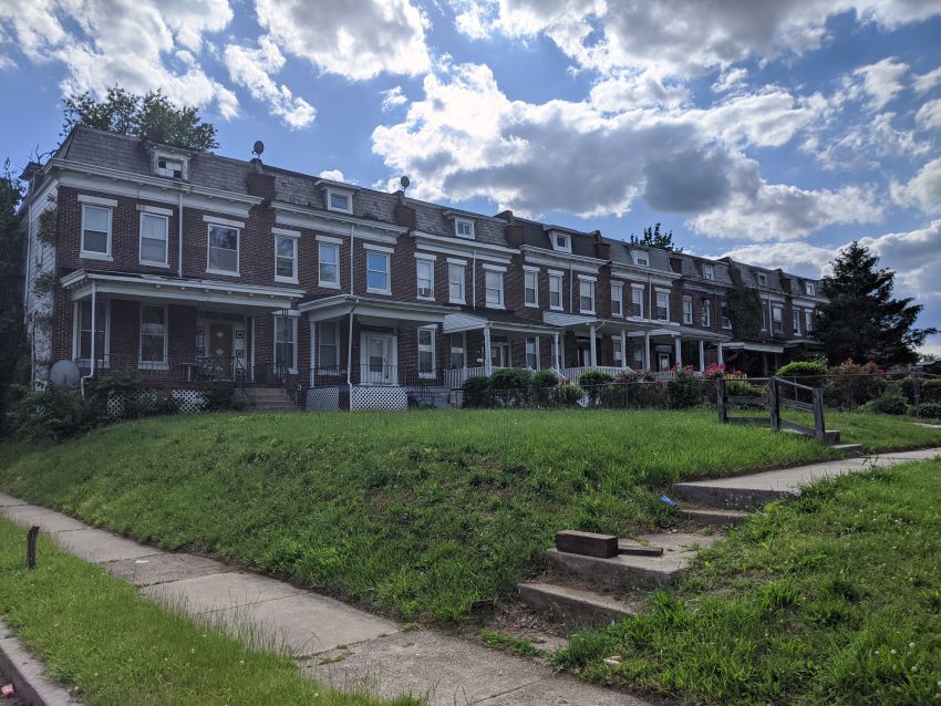
The Park Heights Historic District comprises 7,171 contributing and 246 non-contributing historic resources built between 1906 and 1960 in the large area of Baltimore City north of the Park Circle National Register Historic District. It extends northwards to Northern Parkway, between the Western Maryland rail line on the west and Greenspring Avenue on the east. Developed as a streetcar suburb, the district contains especially fine houses built in the early years of the twentieth century, both pairs and rows of two-story, bay-window porch-front houses, present in both the southern and northern sections of the district. In the period between 1915 and the late 1920s, builders erected rows of “Daylight” houses, followed by a few Tudor rows, and, finally, in the 1940s and 1950s, a number of Early American rows and pairs of houses. All of these houses have front porches and front lawns to appeal to homebuyers who no longer wished to live in the crowded city. Additionally, some of the early developers built individual frame bungalows, two-story houses, or Colonial-Revival houses in the blocks north of Belvedere Avenue and south of Cylburn Avenue, east of Pimlico Road, Reisterstown Road, and Park Heights Avenue, which have long been the commercial corridors of the neighborhood. Some of the most distinctive Art Moderne buildings survive there, but most of the property on these streets has been redeveloped since the 1960s.
|
Significance:
The Park Heights Historic District exemplifies a pattern of development characteristic of Baltimore City neighborhoods from the late nineteenth to the mid-twentieth century. From detached frame houses through dense rowhouses, the district documents the evolution of the concept of “suburb” throughout this period. It derives additional significance for its architecture; its residential rows comprise examples of the range of architectural influences and building types that characterized the city during this period and represent the work of noted and prolific local developers and builders, while its churches and synagogues embody the distinctive designs of prominent Baltimore and D.C. architects. The Park Heights district developed as a classic streetcar suburb outside of Baltimore City in the late nineteenth century, with a railroad line, horsecar line, and finally an electric car line built to bring visitors to the Pimlico Racetrack, established in 1870 in the northeast corner of the district. At first, building developers erected suburban frame houses in both the northern and southeastern sections of the district, and tried to create various neighborhood “suburbs” on either side of the main arteries. The first rowhouses, or paired houses, all with front lawns, began to be built around 1908, in a style known at the time as “bay-window, porch-front” houses. By the 1920s, construction of the newly popular “Daylight” rowhouses dominated the fast-growing suburb, which was beginning to see an influx of Jewish residents moving north from other parts of the city. The entire area became a Jewish neighborhood in the 1920s, with four major synagogues operating between 1921 and 1928. By the late 1960s, many of these Jewish residents had moved further north, and had sold their homes to Black families, many from the Caribbean islands of Jamaica, Trinidad, and Haiti, as eager to escape the confines of the city below North Avenue as the Jewish families had been a generation previously.
|
|
