Photo credit:
Brianna Candelaria, 2023/2024
|
Antietam Farm
Inventory No.:
WA-II-371
Other Name(s):
Gum Tree Farm; Frieze Farm
Date Listed:
2/23/2026
Location:
Mills Road, Sharpsburg, Washington County
Category:
Building
Period/Date of Construction:
1842-1905
Boundary Description:
West Side of Mills Road – Farmhouse
Beginning at a point in the center line of Mills Road, said point being located South 75 degrees. 19 minutes East, 312.07 feet and South 15 degrees 02 minutes 57 seconds West, 100.00 feet respectively from the end of the second line of the lands conveyed to George A. Mills and Alice E. Mills, his wife, and Earl E. Mills and Kimberly L. Mills, his wife, to Richard A. Willis by deed dated July 8th, 1988, and recorded in Liber 882, folio 436, among the Land Records od Washington County, Maryland. Thence continuing with the center line of Mills Road South 15 degrees 02 minutes 57 seconds West, 244.32 feet to a point, thence leaving said road and running along the remaining lands of Richard Willis (Liber 882, folio 436) North 75 degrees 03 minutes 52 seconds West, 800.00 feet to an iron pin set, thence along the same North 20 degrees 07 minutes 31 seconds East, 598.21 feet to an iron pin set, thence along the same South 75 degrees 03 minutes 52 seconds East 800.00 feet to the place of beginning; CONTAINING 11.09 acres of land, more or less.
East Side of Mills Road – Barn, Wagon Shed, Pasture
BEGINNING at a post along the East side of Mills Road, said post being located at the end of the third (or South 75 degrees 19 minutes East 330.00 feet) line of the lands conveyed by George A. Mills and Alice E, Mills, his wife and Earl E. Mills and Kimberly L. Mills, his wife to Richard A, Willis by Deed dated July 8, 1988 and recorded in Liber 882, folio 436 among the Land Records of Washington County, Maryland, thence running with the fourth through the fourteenth lines of the above-mentioned deed South 84 degrees 55 minutes East 173.8 feet to a post, thence South 66 degrees 01 minute East 131.4 feet to a post, thence South 88 degrees 32 minutes East 785.53 feet to a post, thence North 4 degrees 54 minutes East 110.38 feet to a post, thence South 75 degrees 12 minutes East 307.0 feet to an Oak Tree, thence South 77 degrees 26 minutes East 277.0 feet to an Oak Tree, thence North 5 degrees 00 minutes West 18.0 feet to a post, thence South 73 degrees 49 minutes East 281.04 feet to an Oak Tree, thence South 71 degrees 41 minutes East 322.9 feet to a post, thence South 74 degrees 38 minutes East 434.62 feet to a point, thence South 17 degrees 06 minutes West 914.76 feet to an old corner fencepost, thence along lands heretofore conveyed by Richard A. Willis to Ronald Ingram and wife, North 77 degrees 06 minutes 58 seconds West 879.00.feet to an iron pin set, thence along the same South 9 degrees 36 minutes 52 seconds West 217.12 feet to an iron pin set, thence along the same North 75 degrees 59 minutes 04 seconds West 1094.3.7 feet to an iron pin set, thence along the sam7 South 18 degrees 53 minutes 00 seconds West 296.67 feet to an iron pin set, thence along other lands of Ronald Ingram and wife South 18 degrees 53 minutes 00 seconds West 346.31 feet to an iron pin set along the northern marginal line of Harpers Ferry Road, thence with said Harpers Ferry Road, North 59 degrees 49 minutes 00 seconds West 88.29 feet to a post, thence along the same North 73 degrees 52 minutes 00 seconds West 229.56 feet to a post, thence along the same North 80 degrees 03 minutes 00 seconds West 98.46 feet to a post, thence along the same South 84 degrees 34 minutes 00 seconds West 180.00 feet to a point, thence along the same South 89 degrees 22 minutes 00 seconds west 266.48 feet to a point, thence South 62 degrees 30 minutes 00 seconds West 51,64 feet to a point at the intersection of Mills Road, thence along or near the center line of Mills Road North 22 degrees 26 minutes 30 seconds East 149.65 feet to a pin nail set, thence along the same North 26 degrees 18 minutes 46 seconds East 157.72 feet to a point, thence along the same North 24 degrees 55 minutes 31 seconds East 453.21 feet to a point, thence North 26 degrees 17 minutes 23 seconds East 228,25 feet to a point, thence North 23 degrees 36 minutes 41 seconds East 355.50 feet to a point, thence North 15 degrees 02 minutes 57 seconds East 244.32 feet to a point, thence North 15 degrees 02 minutes 57 seconds East 100.00· feet to a point, thence leaving said road and running South 75 degrees 19 minutes 00 seconds East 17,93 feet to the place of beginning, containing 64.45 acres of land, more or less.
|
|
Description:
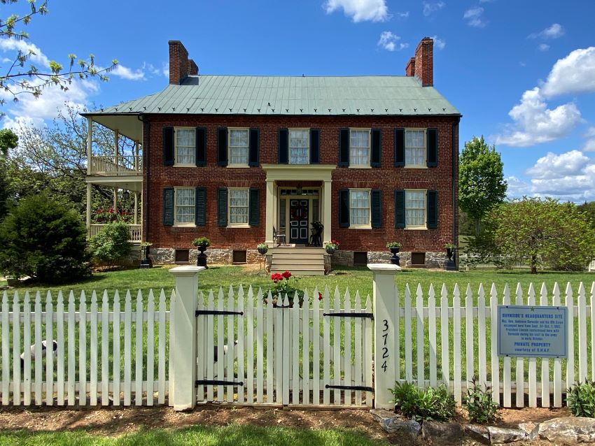
Antietam Farm is located along Mills Road in a rural setting about four miles south of Sharpsburg in Washington County, Maryland. The farmstead consists of a ca. 1844 Federal/Greek Revival brick, two-and-a-half-story, five-bay, double-pile dwelling on an 11-acre parcel on the western side of Mills Road. A non-contributing open five-bay frame equipment shed is located south of the dwelling, and a modern, non-contributing gazebo stands to the west. Contributing farm structures, including a mid-nineteenth-century wagon shed and a brick-and-frame Pennsylvania bank barn, are located on 74 acres on the eastern side of Mills Road. The property is set within rolling hills, pasture, and deciduous trees along the slope of Red Hill, retaining its agricultural viewshed.
|
Significance:
Antietam Farm illustrates Washington County’s mid-nineteenth-century prominence as a wheat-producing region, with the Showman family among the district’s most prosperous agriculturalists and largest enslavers. Agricultural schedules document the scale of production, while later adaptation to dairy farming reflects continuity of agricultural use beyond the Civil War. The property also played a role in the aftermath of the Battle of Antietam as the headquarters of Union General Ambrose Burnside and the site of President Abraham Lincoln’s October 1862 consultation and review of the Ninth Corps. These events underscore the strategic and morale-building functions of the Union Army in the immediate post-battle period. Additionally, Antietam Farm embodies mid-nineteenth century building traditions through its brick farmhouse, which reflects the transition from Federal to Greek Revival styles, and its Pennsylvania bank barn, notable as the largest in the district and distinguished by rare brick outsheds. Comparative analysis with other Sharpsburg-area farmsteads, including Mount Airy, the Hoffman Farm, the Pry House, and the Sherrick House, highlights Antietam Farm’s unusual three-story porch, substantial full basement, and oversized Pennsylvania bank barn as distinctive features. Together, the agricultural, military, and architectural associations of Antietam Farm make it one of the most intact and historically significant farmsteads in the Antietam Valley.
|
|
