Skip to Main Content
Maryland.gov Home
Medusa, Maryland's Cultural Resource Information System
Search
|
Map
|
Reports
|
Back
National Register of Historic Places
Log In
General Information
?
NR Name
: historic name
Alternate Name
: other name(s) associated with this property.
Print
NR Name:
Perry Point Mansion House and Mill
NR Alternate Name:
Address Information
?
Address information in Medusa may differ from information submitted on the original or amended survey form
Address:
Sixth Street
Town:
Perryville
Zip Code:
Counties:
Cecil
USGS Quad(s):
Havre de Grace
Listing Information
NPS Ref Number:
75000883
?
National Register reference number, provided by the National Park Service.
Confidential Location:
(not to be released)
?
Is the location of this resource confidential?
Category:
District
?
Category (Building, Structure, Object, Site, or District)
National Historic Landmark:
Date:
?
Is this listed as a National Historic Landmark? For more details, see www.nps.gov/nhl/
Date Listed:
7/7/1975
Delisted:
Date:
Date Revised:
Multiple Property Submission:
?
Is this a "multiple property submission? If so, what is the name of the multiple property submission?
Multiple Property Submission Name:
Construction Information
Architect/Builder:
Period/Date of Construction:
c. 1750
About This Resource
Capsule Summary Text:
?
Brief description of the resource and its significance, produced by MHT staff for its National Register website (apps.mht.maryland.gov/nr/). This is not necessarily the same as the text description in the actual National Register form, which can be viewed (if scanned) using the Open National Register Form link (below).
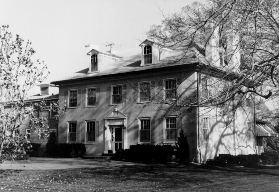
Perry Point Mansion House is a 2 1/2 story, center-passage brick house (covered now with gray stucco) with a hipped roof. The main section is double pile and five bays wide, with a wing to the east. Entrance to the passage is from the north, with the garden door at the south, while the ridgeline of the hipped roof runs east-west. Peaked dormer windows are in each face of the roof, two on the north and south slopes, one at each end between the pairs of chimneys rising inside the end walls from four heating fireplaces on each floor. A fifth chimney rises from the east end of the wing. Windows throughout the house have 6/6 lights, in plain pegged frames except in the rather fancy dormers, where the eaves have a molding, the sides have low-relief pilasters, and the windows facing north or south have an arched top sash. The floor plan, two rooms on either side of the wide passage, is similar on the first and second floors. The wing now has a very well-equipped large modern kitchen. The oblong stone grist mill faces west, three bays by two, with a peaked roof ridgeline running north-south. The mill is built into a river bank and is two stories high on the land side. The river side is three stories, with a basement story. There is a door in the center bay of each story of the river side: on the third floor to hoist in unmilled grain, on the middle level for machinery and other supplies, and on the lower level to deliver finished meal to flat-bottomed boats or carts hauled up a ramp. This is a small mill, about 30' by 20', with well-cut stone masonry still firmly in place. The overshot wheel is now gone, but early pictures show it as about 8' in diameter, about 5' wide, turning beside the north wall, fed by a small island branch with a small watershed dependent on two or three confluent springs. Inside, with the machinery removed, the space is used for garden supplies and tools. Rafters and beams are hand-hewn and pegged, with joists fitting firmly into the large (9" x 12") beams having a well-cut bevel. Inch thick floorboards are of random width. Windows firmly shuttered from the outside have 6 lights over 6. Both the mansion house and the mill, which was built about 1750, serve as fine reminders of a past era. The structures were built during the ownership by the Thomas family, from 1729 until 1800. The next owners were the Stump family, who owned the complex until 1918. Grain from the mill may have been sold to the British during the War of 1812. In 1848, John Stump II sold part of the farm for the right-of-way for the country's major east-coast railroad, now the Penn-Central. Cars were ferried across the river to meet another engine at Havre de Grace. In the bitter winter of 1858 the river froze over solid enough for the tracks to be laid on the ice. In the 1860s John Stump II patriotically turned his farm over to the Union Army for training of Army mules. Officers quartered at the house nearly tore it apart, and seriously neglected the farm. After the war, many of the family's former slaves stayed on voluntarily to rebuild the property. Besides their farming operation and the little gristmill that was also used as a granary, the Stumps engaged in the lucrative fishing industry in the river at their door, drawing nets hundreds of feet long with a capstan on the shore below the house, and selling tremendous catches of fish to Norfolk and to York markets to be salted. They also cut and hauled ice from the river for the icehouses and iceboxes of the neighboring farms and townspeople. A second change occurred in 1918 when the Stump family sold their farm, by then only 516 acres, to the United States Government for $150,000 to be used for the site of a "modern" explosives plant. After the Armistice, Perry Point was used as a rehabilitation center, a supply depot, and a psychiatric hospital, the latter use surviving and expanding to the present.
Boundary Description:
Comments:
Open National Register Form
Enlarge Photo
Michael O. Bourne, 1968
View on MHT National Register Website
Related Records
?
Maryland Inventory of Historic Properties (MIHP), Archaeology (if authorized), Determination of Eligilibity (DOE), and/or MHT Preservation Easement records associated with this record.
Click on hyperlink to go to related record
CE-146
MIHP
Perry Point Mansion House (U.S. Veterans Hospital)
CE-244
MIHP
Perry Point Mill
Easement
No Easement Records
DOE
No DOE Records
Resource Information
?
Resource list associated with this form, if any. Entry of this information into the database is an ongoing project.
NR Form Resource List?:
Resource List Type:
Entered in Database?:
Print
A. That are associated with events that have made a significant contribution to the broad patterns of our history; or B. That are associated with the lives of significant persons in or past; or C. That embody the distinctive characteristics of a type, period, or method of construction, or that represent the work of a master, or that possess high artistic values, or that represent a significant and distinguishable entity whose components may lack individual distinction; or D. That have yielded or may be likely to yield, information important in history or prehistory. a. A religious property deriving primary significance from architectural or artistic distinction or historical importance; or b. A building or structure removed from its original location but which is primarily significant for architectural value, or which is the surviving structure most importantly associated with a historic person or event; or c. A birthplace or grave of a historical figure of outstanding importance if there is no appropriate site or building associated with his or her productive life; or d. A cemetery that derives its primary importance from graves of persons of transcendent importance, from age, from distinctive design features, or from association with historic events; or e. A reconstructed building when accurately executed in a suitable environment and presented in a dignified manner as part of a restoration master plan, and when no other building or structure with the same association has survived; or f. A property primarily commemorative in intent if design, age, tradition, or symbolic value has invested it with its own exceptional significance; or g. A property achieving significance within the past 50 years if it is of exceptional importance.