Skip to Main Content
Maryland.gov Home
Medusa, Maryland's Cultural Resource Information System
Search
|
Map
|
Reports
|
Back
National Register of Historic Places
Log In
General Information
?
NR Name
: historic name
Alternate Name
: other name(s) associated with this property.
Print
NR Name:
Funkstown Historic District
NR Alternate Name:
Address Information
?
Address information in Medusa may differ from information submitted on the original or amended survey form
Address:
Town:
Funkstown
Zip Code:
21734
Counties:
Washington
USGS Quad(s):
Funkstown
Listing Information
NPS Ref Number:
00001050
?
National Register reference number, provided by the National Park Service.
Confidential Location:
(not to be released)
?
Is the location of this resource confidential?
Category:
District
?
Category (Building, Structure, Object, Site, or District)
National Historic Landmark:
Date:
?
Is this listed as a National Historic Landmark? For more details, see www.nps.gov/nhl/
Date Listed:
9/8/2000
Delisted:
Date:
Date Revised:
Multiple Property Submission:
?
Is this a "multiple property submission? If so, what is the name of the multiple property submission?
Multiple Property Submission Name:
Construction Information
Architect/Builder:
Period/Date of Construction:
1767-1950
About This Resource
Capsule Summary Text:
?
Brief description of the resource and its significance, produced by MHT staff for its National Register website (apps.mht.maryland.gov/nr/). This is not necessarily the same as the text description in the actual National Register form, which can be viewed (if scanned) using the Open National Register Form link (below).
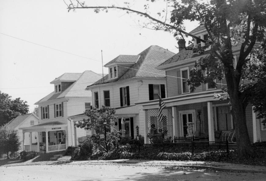
The Funkstown Historic District is located in a horseshoe bend of the Antietam Creek in Washington County, Maryland. The National Road forms Funkstown's main street (Baltimore Street) and shaped in a significant way the appearance of the town. Funkstown's early and most extensive development was along this route, including the town's oldest known dwelling, the Jacob Funk House, built by the founder in 1769. Other properties are of sided log, stone, or brick construction of mixed residential and commercial use, dating from the late 18th century through the mid 20th century. The streets are laid out in a grid pattern terminating at the creek at the north, south, and west sides. Industrial sites including a grist mill, powder mill, paper mill, and a woolen mill were located along the creek. None of these industries has survived but their sites are known and they may yield archeological data. Architecturally, the district exhibits examples of colonial Germanic, Georgian, Federal, Greek Revival, and Italianate styles, along with later developments such as Queen Anne, Foursquares, Bungalows, and 'Cape Cods.' the district includes 217 contributing buildings, 1 contributing structure, and 3 contributing sites. There are 182 non-contributing buildings, mostly infill development less than 50 years old. The majority of these later buildings are located along the secondary streets. The Funkstown Historic District reflects a unique set of events or conditions that created the community's patterns of development. The power source provided by the Antietam Creek led to a variety of industries which were established early at this location. The textile industry was prominent among these causing Funkstown to be one of the early centers of the manufacture of Brussels carpet in America. The old wagon road, the main route from Baltimore to the west had a tremendous impact on the town. As it eventually became part of the National Pike in the 1820s, the town experienced rapid growth along the route (Baltimore Street) with hotel and tavern business predominating. Civil War history also impacted Funkstown. The July, 1863 Battle of Funkstown was an important delaying tactic by the Confederates. The resulting casualties were cared for by the citizens of Funkstown. The town's citizens were very divided in their sentiments, pro-South and pro-North. Funkstown's particular history is reflected in its architecture and other historic resources, giving it historic significance in the areas of transportation, military, and industrial development, and for its architectural character, representing adaptations of several important styles and types.
Boundary Description:
West Side Ave. to Stouffer Ave. Poplar to Green St.
Comments:
Open National Register Form
Enlarge Photo
Edith B. Wallace, 10/1999
View on MHT National Register Website
Related Records
?
Maryland Inventory of Historic Properties (MIHP), Archaeology (if authorized), Determination of Eligilibity (DOE), and/or MHT Preservation Easement records associated with this record.
Click on hyperlink to go to related record
WA-I-529
MIHP
Funkstown Historic District (Jerusalem)
Easement
No Easement Records
DOE
No DOE Records
Resource Information
?
Resource list associated with this form, if any. Entry of this information into the database is an ongoing project.
NR Form Resource List?:
Resource List Type:
Entered in Database?:
Print
A. That are associated with events that have made a significant contribution to the broad patterns of our history; or B. That are associated with the lives of significant persons in or past; or C. That embody the distinctive characteristics of a type, period, or method of construction, or that represent the work of a master, or that possess high artistic values, or that represent a significant and distinguishable entity whose components may lack individual distinction; or D. That have yielded or may be likely to yield, information important in history or prehistory. a. A religious property deriving primary significance from architectural or artistic distinction or historical importance; or b. A building or structure removed from its original location but which is primarily significant for architectural value, or which is the surviving structure most importantly associated with a historic person or event; or c. A birthplace or grave of a historical figure of outstanding importance if there is no appropriate site or building associated with his or her productive life; or d. A cemetery that derives its primary importance from graves of persons of transcendent importance, from age, from distinctive design features, or from association with historic events; or e. A reconstructed building when accurately executed in a suitable environment and presented in a dignified manner as part of a restoration master plan, and when no other building or structure with the same association has survived; or f. A property primarily commemorative in intent if design, age, tradition, or symbolic value has invested it with its own exceptional significance; or g. A property achieving significance within the past 50 years if it is of exceptional importance.